Riverquest I: The Mighty Peckman
Ever wonder where a river goes? Where it starts? If you're reading this, I bet the answer is probably. Rivers are important! They direct surface runoff and have a multitude of uses for many species. We often see rivers in small segments throughout our day-to-days, but what about the whole picture? This is my quest (the Riverquest) to learn about the whole picture, including some features and history. And I'm sharing it with you, the reader! Hello, thank you for reading. I hope you find this as interesting as I do.

The Peckman River in its entirety (blue) in the Peckman River watershed (yellow)
Photo from USGS StreamStats
What's a peckman?
The Peckman River is a tributary of the Passaic River in New Jersey. Situated in the valley between the First and Second Watchung mountains, its source lies in Eagle Rock Reservation, but the exact location of the source differs by map. From the reservation it flows west and northward through Verona, Cedar Grove, Little Falls, and Woodland Park where it converges with the Passaic. It is sometimes thought to be named after the Lenape word for cranberry, "pakim" (like Pakim Pond in Woodland NJ), but its source is most likely the surname of a local English settler. [1]
There are a few notable features along the Peckman River, including Devil's Hole in Cedar Grove and Verona Lake in Verona, that are integral to the history of the surrounding area.

The mouth of the Peckman River in Woodland Park
devil's hole
![Location of Devil's Hole in Cedar Grove [Photo courtesy of Google]](https://images.squarespace-cdn.com/content/v1/58a3c20503596e0fdbb17de3/1525028355384-X40K746CHW47QV69K2LX/devils+hole.png)
Location of Devil's Hole in Cedar Grove [Photo courtesy of Google]
Originally the site of an old factory that made steel corset stays for the Van Orden Corset Company, the water from Devil's Hole was the main source of power for the factory, which used a steam boiler. Since razed, Devil's hole had become a popular swimming destination, but after several recent incidents swimming has been prohibited. The remnants of the factory and the dam that was built alongside it can still be seen today. [2]

Peckman River in Cedar Grove before Devil's Hole

Me posing with the Devil's Hole waterfall

Devil's Hole waterfall

Some of the remnants of the factory along the Peckman
verona lake
![Location of Verona Lake waterfall in Verona [Photo courtesy of Google]](https://images.squarespace-cdn.com/content/v1/58a3c20503596e0fdbb17de3/1525028628528-VN2E2JN7HEOWGSMUGZA5/verona+lake.png)
Location of Verona Lake waterfall in Verona [Photo courtesy of Google]
In the 1800s, the Peckman River was dammed in Verona in order to power a grist mill. With the tract of land surrounding this area of the river being swampland, the beginnings of a lake were formed as a result of the damming. Soon this area became a prime recreation spot, hence known as Verona Park, and a small falls remains to this day where the lake flows back into the Peckman River. [3]

Verona Lake (north)

Verona Lake (south)

Verona Lake waterfall
finding the source
Verona Lake is the farthest major area from the mouth of the Peckman River, but what of beyond that? Where is the source? The river winds through a golf course to reach Verona Park, but beyond that, according to Google maps, it seems to end abruptly in a residential area in West Orange, near Eagle Rock Avenue.

To get a better picture of where this might be sourced, I used the application StreamStats from the United Stats Geological Survey (USGS). With this application, I was able to delineate the drainage basin (watershed) of the Peckman river, shown at the top. This is done by tracking multiple high points around a river, where its tributaries begin. The application was able to give a more accurate picture of the source of the Peckman River. According to StreamStats, it is situated in Eagle Rock Reservation, which is closer to the edge of the watershed.

USGS Peckman River
With this picture and the help of the Google maps satellite view, I was able to make an estimate of where the source of the Peckman River should be. It doesn't perfectly match the USGS delineation, but both end at the same location: a small dark patch in Eagle Rock Reservation.
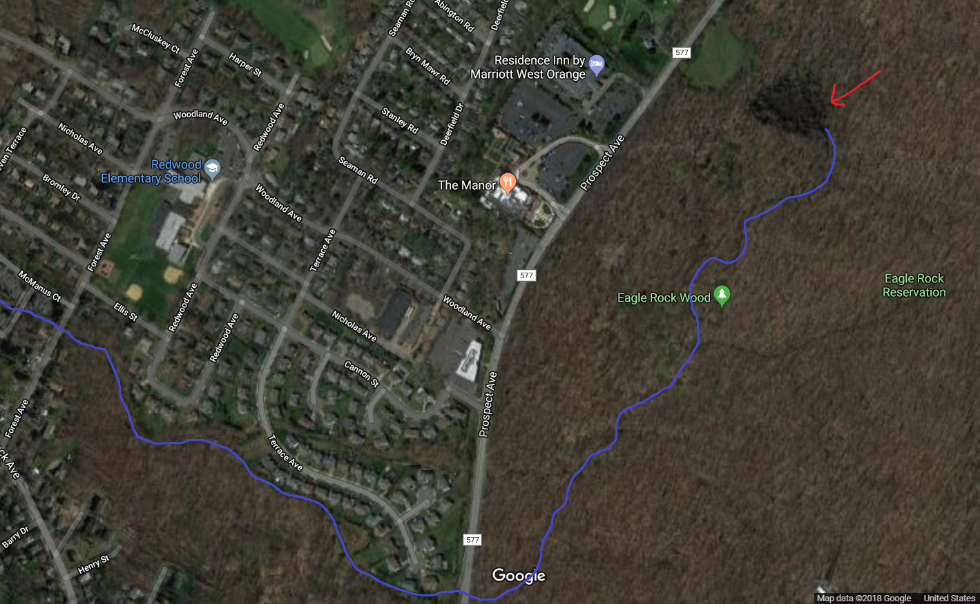
Peckman River via Google Maps satellite view
the source

The Peckman River just before the wetlands

The closest I could get to the source
Just off the Blue Trail, the source of the Peckman River looks to be wetlands, guarded by thickets on all sides. I don't know if there is a spring here or if it's where rainwater in the reservation mostly collects, but regardless it's the source of the river's flow. This is the true beginning of the Peckman River.
the end
Thanks for joining me on this Riverquest! Let me know what you think if you want and see you next time. If you want to read more about the river and the history that happened around it, check out the section below!
sources/further reading
[1]: Manhattan to Minisink: American Indian Place Names of Greater New York and Vicinity by Robert S. Grumet
[2]: Environmental Resource Inventory: Township of Cedar Grove
[3]: About Verona Park